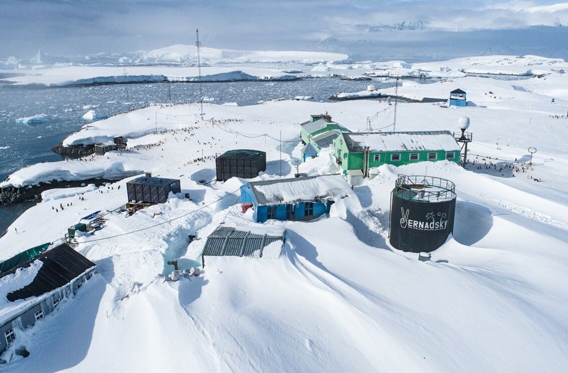
Address

Station manager

Contact Station

Station Features

Opening year: 1995 Status: Open
  • Type of station: Station
  • Operational period: year-round
  • Name of station owner: National Antarctic Scientific Center of Ukraine
  • Type of owner: Government, Research institution
  • Name of managing institution: National Antarctic Scientific Center of Ukraine
  • Managing Institution Country: Ukraine
  • Station owner country: Ukraine
  • Partner institution: No
  • Station latitude: -65,24580000
  • Station longitude: 295,74220000
  • Region (station location): Antarctic Peninsula
  • Altitude of station: 7 m a.s.l
  • Type of surface facility is built on: Ice-free ground
  • Climate zone: Maritime Antarctica
  • Mean annual temperature: 3,8 °C
  • Mean temperature in February: 0,6 °C
  • Mean temperature in July: -8,7 °C
  • Precipitation type: Snow and rain
  • Snow free period (month to month): February, March
  • Sea ice break up: December
  • Dominant wind direction: North
  • Mean annual wind speed: 15,4 m/s
  • Maximum wind speed (absolute): 144 m/s
  • Geomorphological Coast, Moraine, Sea, Shoreline, Other
  • Permafrost zone Continuous
  • Wildlife Bird colonies, Seal colonies, Other biological
  • Antarctic Conservation Biogeographic Region North-west Antarctic Peninsula
  • Antarctic Environmental Domain Antarctic Peninsula offshore islands (e.g. most of Deception Island)

Facilities

  • Number of staff peak season/summer: 10
  • Number of staff off season/winter: 5
  • Area under roof: 1150 m²
  • Max. number of visitors at a time : 24
  • Showers: Yes
  • Laundry facilities: Yes
  • Power supply - period: 24 hours per day
  • Power sources at station Diesel/oil/gas
  • Waste management: Yes
  • Hazard(ous) management: Yes
  • Logistics area: 385 m²
  • Conference room capacity: 0
  • Workshops Electrical and IT technologies, Metal, Wood
  • Means of transportation to/from station Boat
  • Transport on land - at station Snowmobile
  • Transport on water - at station Zodiac, Open boat/Dhinghy
  • Number of airstrips: 0
  • Length (m) of longest runway: 0
  • Number of ship visits per year: 40
  • Period of ship visits per year: January, February, March, December
  • Number of flight visit per year: 0
  • Specific device/Scientific equipment: Meteorological equipment and recording devices (mobile meteorological complex), marine and hydro- meteorological equipment (mechanical and automatic mareographs, oximeter, bathometer, bottom sampler, manual coring winch), biological equipment
  • Laboratory area: 180 m²
  • Communications E-mail, Satellite telephone, VHF
  • Medical facilities: Yes
  • Medical capability Basic, Dental, Surgery
  • Area of medical facilities (m2): 26 m²
  • Medical equipment Electrocardiograph, Electroencephalograph, Reflotron (biochemical laboratory)
  • Staff with basic medical training or doctor (Summer): Yes
  • Staff with basic medical training or doctor (Winter): Yes
  • Closest emergency facility in Antarctica: 0 km
  • Closest emergency facility external: 0 km
  • Medical research capabilities: Yes
  • Medical screening requirements: Yes

Science

  • Transnational Access: No
  • Remote Access: No
  • INTERACT Virtual Access: No
  • Partner institutions (involved in the operation of the station)
    • Partner institution
  • Climate
    • Snow
    • Rain
    • Hail
  • Landscape and environment
    • Bluff
    • Clear air zone
    • Coast
    • High elevation
    • Low artificial light pollution
    • Fjord
    • Low humidity
    • Hill
    • Other Atmospheric
    • Lake
    • Melt streams
    • Moraine
    • Mountain
    • Permanent snowpatches
    • Plateau
    • Rock
    • Sea
    • Shoreline
    • Terrestrial geothermal
    • Valley
    • Nunataks
    • Crevasse
    • Ice cap
    • Glacier
    • Blue ice
    • Ice shelf
    • Ice tongue
    • Sea-ice
    • Snow
    • Sustrugui
    • Other
    • Continuous
    • Discontinuous
    • Sporadic
    • None
    • Bird colonies
    • Seal colonies
    • Other biological
    • North-east Antarctic Peninsula
    • South Orkney Islands
    • North-west Antarctic Peninsula
    • Central south Antarctic Peninsula
    • Enderby Land
    • Dronning Maud Land
    • East Antarctica
    • North Victoria Land
    • South Victoria Land
    • Transantarctic Mountains
    • Ellsworth Mountains
    • Marie Byrd Land
    • Adelie Land
    • Ellsworth Land
    • South Antarctic Peninsula
    • Prince Charles Mountains
    • Antarctic Peninsula northern geologic
    • Antarctic Peninsula mid-northern latitudes geologic
    • Antarctic Peninsula southern geologic
    • East Antarctic coastal geologic (e.g. Vestfold, Bunger, Wilson hills)
    • Antarctic Peninsula, Alexander (and other islands main ice fields and glaciers)
    • Larsen Ice Shelf (also includes Prince Gustav and other northern peninsula ice shelf remnants)
    • Antarctic Peninsula offshore islands (e.g. most of Deception Island)
    • East Antarctic low latitude glacier tongues (e.g. Mertz, Rennick)
    • East Antarctic ice shelves (e.g. Fimbulisen, Amery, Shackleton, Cook, Moubray Bay)
    • Southern latitude coastal fringe ice shelves and floating glaciers (e.g. Pine Island,Thwaites, Getz, Drygalski)
    • Northern latitude ice shelves (e.g. Wordie, George VI, Wilkins, Abbot, Riser-Larsenisen, Nansen)
    • Continental coastal-zone ice sheet
    • Continental mid-latitude sloping ice (e.g. Ellsworth & Coats lands, upper Lambert Gl, northern Berkner & Thurston islands)
    • East Antarctic inland ice sheet
    • West Antarctic Ice Sheet (also includes inland Coats Land, Taylor Dome, Ross Island ice cap)
    • Ross and Ronne-Filchner ice shelves
    • East Antarctic high interior ice sheet
    • Transantarctic Mountains geologic (Shackleton Range to Cook Mountains)
    • McMurdo - South Victoria Land geologic (also includes Ellsworth, Werner etc mountains)
    • Inland continental geologic (Dronning Maud, MacRobertson, Victoria, Oates lands, Ford Range)
    • North Victoria Land geologic (also includes Executive Committee Range, Prince Charles & Jones mountains)
  • Housing and accomodation
    • Showers
    • Laundry facilities
    • Municipal grid
    • Diesel/oil/gas
    • Wood
    • Solar
    • Wind
    • Water
    • Geothermal
    • Biofuel
    • Other
    • Waste management
    • Hazard(ous) management
  • Logistics
    • Electrical and IT technologies
    • Mechanical
    • Metal
    • Wood
    • Plexiglas
    • Other
    • Walk
    • Tracked vehicle
    • Truck
    • SUV (4x4)
    • Car
    • Zodiac
    • ATV
    • Snowmobile
    • Open boat/Dhinghy
    • Closed boat
    • Bicycles
    • Amphibie vehicle
    • Ski
    • Other
    • Snow shoes
    • KickSledges
    • Other
    • Ski
    • Snowmobile
    • Boat
    • Car
    • Tracked vehicle
    • Truck
    • SUV (4x4)
    • Bus
    • Train
    • Scheduled flight
    • Chartered plane/helicopter
    • Other
    • None
    • Harbour/port
    • Warf/pier
    • Pontoon/float bridge
    • Barges
    • Beach
    • Hydroponics facilities
    • Helipad
  • Laboratory
    • Freezer < -80
    • Freezer -40 - -10
    • Fridge
    • Microscopes
    • Basic laboratory equipment
    • Advanced laboratory equipment
    • Basic chemical reagents
    • Analytical instrumentation
    • Other
  • Communication and IT
    • Computer
    • E-mail
    • Fax
    • Internet
    • Printer
    • Satellite telephone
    • Scanner
    • Telephone
    • VHF
  • Medical facilities
    • Medical facilities
    • Basic
    • Medium
    • Extensive
    • Dental
    • Surgery
    • Other
    • Aeromedical equipment
    • Altitude medicine
    • Anaesthesia
    • Biochemistry
    • Blood transfusion medicine
    • Diagnostic X-ray
    • Diagnostic ultrasound
    • Endoscopy
    • Haematology
    • Hyperbaric recompression chamber
    • Laboratory diagnostics
    • Microbiology
    • Ophthalmology
    • Telemedicine
    • Other
    • Staff with basic medical training or doctor (Summer)
    • Staff with basic medical training or doctor (Winter)
    • Medical research capabilities
    • Medical screening requirements

Station name and owner

Akademik Verdadsky Station is operated by the National Antarctic Scientific Center of Ukraine.

Location

Vernadsky station is located at Marina Point Galindez Island, Argentine Islands Archipelago, Kiev Peninsula, Antarctic Peninsula. The Antarctic Specially Protected Area (ASPA) 108 “Green Island, Berthelot Islands, Antarctic Peninsula” is situated 9 km to the South from Vernadsky. CEP Visitor Site Guidelines for nearest islands: Winter I., Petermann I., Pleneau I., Booth I., Yalour I. The station is located in the vicinity to relict Galindez Island Ice Cap (Woosle Hill), 51 m height.

Climate data

Grey colours are WMO Climate Normals including maximum and minimum values. Blue colours are individual years.

Export to PDF

Climate data for the stations where extracted via Copernicus Climate Data Store, from the global gridded reanalysis product:
ERA5 monthly averaged data on single levels from 1940 to present. Description and source code: Roemer J.K. 2023. https://doi.org/10.5281/zenodo.10214922 Data Source: Hersbach et al. 2023. Copernicus Climate Change Service (C3S) Climate Data Store (CDS), https://doi.org/10.24381/cds.f17050d7

Biodiversity and natural environment

Fauna: The following species are regularly sighted on the Island: Adélie penguins (Pygoscelis adeliae), Gentoo penguins (Pygoscelis papua), Blue-eyed shags (Phalacrocorax atriceps), Wilson’s storm-petrels (Oceanites oceanicus), South polar skuas (Catharacta maccormicki), Kelp gulls (Larus dominicanus) Weddell seals (Leptonychotes weddellii). Flora: Rhizocarpon sp. and Usnea Antarctica lichens are present on the island. The moss Polytrichum strictum is also found.

History and facilities

In 1995 the British Faraday station was transferred to Ukraine under the Memorandum of Understanding between the British Antarctic Survey and the State Institution National Antarctic Scientific Center of Ukraine (July 20, 1995). February 6, 1996 the Ukrainian State Flag was raised and the station was renamed to Vernadsky.

General research and databases

Monitoring of environmental parameters in the Antarctic region, at all levels of geosphere – from tectonosphere to geospace – and their transfer to the national and international centers of scientific data (WMO, INTERMAGNET, MAGATE, BAS), including: research of the Earth magnetic field, radio sounding of the ionosphere in the Southern Polar region, hydro-meteorological research, geophysical research of the Earth lithosphere, research of the West Antarctic biosphere, medical and physiological research.

Station Monitoring

Human dimension

Access

Member of:
  • Polarin